
![]()
On January 1, 2017, I decided to write a book that combined my love of writing, history, trains, and photography. With a tentative title of “On Time: A Timeline of Railroads in San Diego County,” I’m finding that it keeps me busy and I don’t seem to get bored.
 Right now it’s just a lot of reading and research. I started in the San Diego Central Library (left) because I found that they have microfilm of the new San Diego newspapers—Herald, Union, Tribune, Union-Tribune—all the way back to 1851, which was 18 years before the completion of the Union Pacific/Central Pacific transcontinental railroad at Promontory, Utah.
Those 18 years in the San Diego newspapers indicate that San Diego was hoping to be what San Francisco became. It never happened because, basically, no one could agree on a good route through the Santa Rosa Mountains and the Colorado Desert from Yuma AZ to San Diego.
Not that people weren’t trying.  Even after the transcontinental railroad was completed in 1869, people kept trying to build a southern competitor. It looked like it might happen when John D. Spreckels, the owner of the San Diego Union, said that he would build it. And he did. The San Diego & Arizona Railway (SD&A). Also known as “The Impossible Railroad.”
The SD&A’s history is so convoluted (which is why I’m writing this book) that the only thing I can determine for sure at this point is that the SD&A was chartered on December 14, 1906; groundbreaking ceremonies were held on September 7, 1907; and construction was completed on November 15, 1919. Final construction cost was $18 million, three times the original estimate of $6 million.
There are 129 miles. The 11-mile segment through Carrizo Gorge included 17 tunnels stretching 13,385 feet, and 2½ miles of bridges and trestles.
The SD&A was never profitable, mainly because tunnels kept collapsing and trestles were washed away from winter rains. Although there is, to this day, hope for re-opening the line, there are two main problems: First, the cost to repair the damaged tunnels and trestles is estimated at $5.5 million. Second, there are 44 miles of track in Mexico. Yep. Mexico. A hundred years ago there was no border wall and people easily moved back and forth between the two countries.
In today’s world with Twitler as the United States president, I think there is no way anyone anywhere is going to approve a train leaving San Diego, entering Mexico at Tijuana and re-entering the United States at Tecate, 44 miles away. Nope. Ain’t gonna happen. That’s based on my early youth when I was hopping trains between Brigham City and Ogden UT, and Kingsville and Bishop TX.
So, while we’re waiting for Twitler to be impeached, we have to content ourselves with tourist rides on a 5-mile section of the old line courtesy of the Pacific Southwest Railway Museum.
Early in January 2017, I took a driving tour of the SD&A tracks all the way out to Plaster City, a distance of about 90 miles. A month later, a friend who owns a helicopter service took me on a 3-hour flight out to the Santa Rosa Mountains to check out the SD&A railroad from the air. Following are some pictures from both my adventures.
This first picture is near Jacumba Hot Springs and shows the SD&A tracks going under a bridge built in 1932 for old U.S. Highway 80.

The border wall with Mexico is about one hundred feet away, with a maintenance gate:

I walked over to the gate and had about a million Border Patrol and Homeland Security agents descend on me. After talking with me for a few minutes and looking at pictures on my camera, one officer said into his walkie talkie: “Stand down. Local tourist.” Another officer informed me that with a new car with “paper plates” (temporary plates), I’d probably be stopped several times. I was. Six times in 90 miles.
Note that San Diego County already has built its border wall with Mexico, and we had no help from anyone else, not even Mexico. Thus, we’re not going to help other counties build their walls.
This next picture is of a switch engine marked as Carrizo Gorge Railway 1465:

Carrizo Gorge Railway operated the SD&A tracks between Tecate and Plaster City from 1997 to 2012. This locomotive is tied up in court between Carrizo Gorge Railway and the engine’s owners, the East County Dirt Works. It sits at the old depot in downtown Jacumba where a lot of other rolling stock also sits, deteriorating in the hot desert sun.

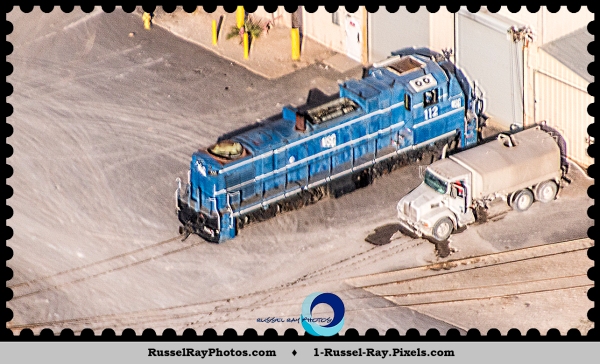
My goal on my driving tour was to make it to Plaster City CA, which is nothing but a gypsum plant for USG. However, USG operates that last remaining commercial narrow gauge railroad in the United States. Standard gauge tracks like you see every day are 4’8½” between the rails. Narrow gauge tracks can be anything narrower than that; the USG narrow gauge tracks are a mere 3′, making the rolling stock somewhat small compared to the big boys. As we flew over Plaster City in the helicopter, I got a picture of USG 112, a narrow gauge locomotive:
And the narrow gauge tracks leading from the gypsum quarry to Plaster City in the upper right:

The flight over the Carrizo Gorge where all the tunnels and trestles are was pretty cool. The main sight in Carrizo Gorge is the Goat Canyon Trestle:

At about 180′ high and 630′ long, the Goat Canyon Trestle is the largest wooden trestle in the world. The trestle was built in 1932 when the tunnel, directly in the center behind the trestle, collapsed. At the left is an abandoned hopper car.
It’s pretty neat to see all the trestles from the air, indicating just how desolate and isolated this area is, and how difficult it is to maintain the tracks.

All along the route are abandoned railroad cars. In some cases it’s obvious why they are abandoned:

The Pacific Southwest Railroad Museum in Campo CA uses the old Campo Depot as its headquarters and has a lot of rolling stock that it is restoring. They offer rides on historic trains over about 5 miles of track, although the rains we have had this winter have, again, washed out some tracks, so those train rides are on hold. Here’s Pacific Southwest Railroad Museum from the air:

Map of the San Diego & Arizona Railroad:


This post approved by


It’s fascinating! Whether or not you ever get the books completed, aren’t you glad you’re working on it? Projects like that get us out and make us go in new directions we wouldn’t try otherwise!
I hope you don’t get picked up for your suspicious spy-like behavior though! 🙂
LikeLike
A decade ago when San Diego County was building the wall, I went out to take pictures. Seven Border Patrol cars were following me. After about 5 miles, they surrounded me and told me that I couldn’t take pictures. Uh, I was on a public road taking pictures of a public structure. I didn’t argue with them, though, and they made me delete all my pictures. They all left, and I did a U-turn and took pictures all the way back. Just wasted time but a lot of fun.
LikeLike
Wow, Russell. I’m thrilled you’ve decided to write a book, but I’m also amazed at that country. For some reason I assumed your state was semi-tropical and ‘lush’ [maybe thanks to your flower photos]. Anyway, that country is heading towards desert isn’t it?
LikeLiked by 1 person
East San Diego County is the Santa Rosa Mountains and the Colorado Desert. We can go from beaches to mountain snow to dry desert in just 90 miles, or to put it into temperatures: 72°F to 22°F to 112°F. Here in the San Diego metroplex we have what is called a “desert Mediterranean climate.” In other words, we don’t get much rain (the desert part) but we don’t get extreme temperature fluctuations very often. I’m so spoiled now that it’s too hot if it’s over 80°F and too cold if it’s under 60°F.
LikeLike
What an amazing place. I have to admit I wouldn’t mind that ‘desert Mediterranean climate’. We get used to high temps here in summer, but it’s always a case of grit your teeth and bear it.
LikeLike
I’ve lived in many places where I had to grit my teeth and bear it. I think that’s why I’m so spoiled here in San Diego.
LikeLike
Yeah, it sounds pretty ideal. 🙂
LikeLike
I’m wondering why you are calling that area Santa Rosa Mountains. I’ve never heard of that so I looked it up on Wikipedia and it seems that the Santa Rosa Mountains are more to the north; though the picture shows they do extend south.
We’ll have to stop by Jacumba and see the locomotive. I didn’t notice an old train depot last time we were there. Too bad my brother gave up waiting for them to fix him a sandwich in the store, I might have had more time to explore.
LikeLike
The Depot is at the north end of Railroad Avenue.
What do you know the Santa Rosa Mountains as? When I bought a home in Spring Valley in 1999 the real estate disclosures called them the Santa Rosa Mountains and I haven’t found any other name for them. My railroad books about the SD&A also call them the Santa Rosa Mountains.
LikeLiked by 1 person
I’d never heard of them at all. I just thought of that mountainous area as the Laguna Mountains or Mount Laguna and the whole area as the Cleveland National Forest. I was thinking that maybe this is one of those things that everyone knows but for some reason I never knew. So I asked my dad if he had heard of them and he hadn’t. And he is always driving around out there are looking for geocaches and studying maps.
Anyway, I’m glad to learn something new and I’m going to ask others what they call the area and if they’ve heard of the Santa Rosa Mountains. 🙂
LikeLike
The Laguna Mountains are actually part of the Santa Rosa Mountains, which actually is properly named the Santa Rosa Mountain Range. I was in the Laguna Mountains and the Santa Rosa Mountains, so I used the range name since it comprises everywhere I went. There actually is no Mount Laguna as a topographic feature; that’s the name of the village where the Laguna Mountain Lodge is on Sunrise Highway. Chris Wray’s book, “The Historic Backcountry: A Geographjic Guide to the Historic Places of the San Diego County Mountains and the Colorado Desert” is a great reference because it cites maps and has lat/long coordinates.
LikeLike
Facinating!
LikeLike
Long time no see. You’re looking good.
LikeLike
Brilliant post! Those trains are amazing and get photos. Those are some railway tracks 😎We don’t have that sort of land for ours to travel across but I wish we did 😃Oh….that’s an awesome library you have there too! Greet architecture 😊
LikeLike
Pingback: Out & About—Old Highway 80 & the best. chocolate. ever. | Russel Ray Photos