Tag Archives: mission san diego de alcala

You can see their fort from our fort

Out & About

Since we finished exploring San Diego Historical Landmarks #1 and #2, I had to go out and about to get pictures of #3.

Landmark #3 is right next to #4, so I was able to get two sets of pictures in just one trip. Yahoo for saving gas!

As I wandered around #3 and #4, which have awesome views from up on high, I saw across the way this structure:

University of San Diego

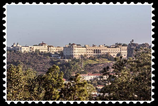
That is part of the campus of the University of San Diego, a private Catholic-affiliated university of about 5,500 students founded in 1949.

Looks kind of like a fort. Imagine a fort manned by men and women who are mostly 18-22 years old. Hmmm. Sounds just like the United States military….

To take that picture, I was standing at the site of the Presidio:

Presidio in San Diego

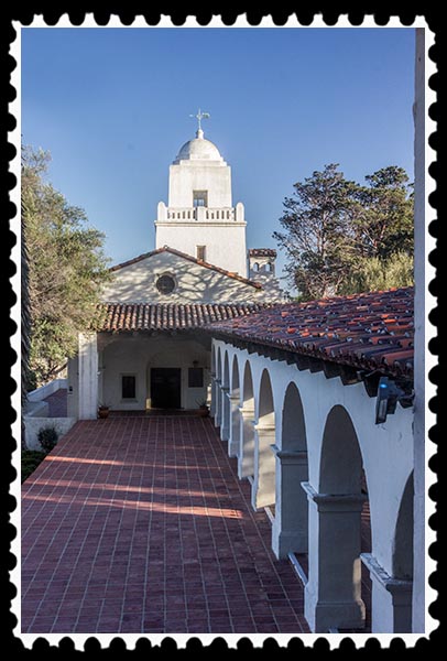
The Presidio was built in 1769 and was the first permanent European settlement on the Pacific Coast of the present-day United States. It was the base of operations for the Spanish colonization of California. It was a fort.

There are no structures left from the original Presidio. What often is referred to as the Presidio, shown above, is actually the Serra Museum, built in 1928-29 on the site of the original Presidio. It is named after Father Junipero Serra (1713-1784), founder of Mission San Diego de Alcalá, the first mission in California, and eight other missions.

The Serra Museum was built by George Marston (1850-1946), a wealthy department store owner. He had bought Presidio Hill with an intent to preserve the site. The building was designed by noted San Diego architect William Templeton Johnson (1877-1957) in Spanish Revival style to house the collection of the San Diego Historical Society. (For more about William Johnson, see San Diego Historical Landmarks #1, part 6, part 8, and part 10.)

Marston donated the museum and surrounding park land to the city of San Diego in 1929.

Sadly, city budget cuts during the Great Recession caused the Serra Museum to be unstaffed and closed. Those cuts have not been fully restored, so the Museum is open only on Saturdays and Sundays from 10:00 a.m. to 5:00 p.m.. That’s where I will be in a few of days in order to get more pictures of San Diego Historical Landmark #4.

Pictures copyright 2012 Russel Ray Photos

This post approved by
This post approved by Zoey the Cool Cat

Do you have Bare Wall Syndrome? Need a unique gift?
Choose Photographic Art by Russel Ray Photos at Fine Art America.

photograhic art taking pictures making art

San Diego Historical Landmarks—#2: Old Mission Dam

San Diego Historical Landmarks

It took eighteen posts to explore San Diego’s Historical Landmark #1! Now that we’re finished, the other landmarks should be much faster. However, the most recent list I have right now, dated May 26, 2011, has 999 historical landmarks, so if I did one post per day, we’d be here for three years! I’m not doing one post per day just on historical landmarks, so it’s probably going to be more like five or ten years. We best get busy!

San Diego Historical Landmark #2 is the Old Mission Dam & Flume at Padre Dam. Looks like this:

Padre Dam in San Diego, California

Pictures copyright 2012 Russel Ray Photos

The Old Mission Dam was the first major irrigation project on the Pacific Coast. It is located on the San Diego River as it runs through what is now Mission Trails Regional Park, the largest municipal park in California.

Mission Trails Regional Park

Pictures copyright 2012 Russel Ray Photos

That’s my shadow in the bottom right corner. Does that count as a selfie?

The wall welcoming you to the nearest entrance to the park has a representation of the San Diego River on it.

Mission Trails Regional Park

Pictures copyright 2012 Russel Ray Photos

In the following Photographic Art, titled “Purple Mountains Majesty,” the green coursing through the canyon between the mountains is the San Diego River and the location of the Old Mission Dam.

Purple Mountains Majesty

Also called “Padre Dam,” the stone and cement dam is 220 feet long, 13 feet wide at its base and 12 feet high. Water was released from the dam for a sawmill and irrigation at the Mission San Diego de Alcalá, California’s first mission, six miles away.

Following is more about the dam, and I have put the graphic into words below it for my foreign readers since Google Translate can’t translate text on a graphic.

Old Mission Dam in San Diego, California

Pictures copyright 2012 Russel Ray Photos

From the above graphic:

In the early 1800’s, the Spanish saw the need to control the flow of water and to provide it year-round for their permanent settlements. To solve this problem, engineers trained in Mexico supervised Kumeyaay Indian laborers in building one of the first major irrigation projects in the western United States.

The 250-foot long Old Mission Dam (formerly known as Padre Dam) was built 8 to 10 feet wide and nearly 12 feet high, using ropes, pullies and hand labor. Rocks and boulders were cemented together with a mortar made of lime and crushed seashells.

The reservoir created by the dam was three football fields long. A flume, lined with hand-made clay tiles, was built along the north side of the river to deliver water to the head of the Mission’s crop fields (located where the Admiral Baker Golf Course is today), about three miles downstream from the dam. From the fields, a 2.5 mile clay-lined ditch carried water the remaining distance to the Mission, where it was then stored in a tank on site.

To protect this unique and historic engineering achievement, the Old Mission Dam was registered as both a National Historic Site, as well as a California State Historic Landmark.

A Google map showing the dam and the Admiral Baker Golf Course:

Google Maps

Go to location on Google Maps

Pictures copyright 2012 Russel Ray Photos

Mission San Diego de Alcalá was founded in July 1769, and the dam was built as early as 1803 (source: List of San Diego Historical Landmarks) and as late as 1813-1816 (all other sources). I’m going with 1813-1816.

Old Mission Dam in San Diego, California

Pictures copyright 2012 Russel Ray Photos

Old Mission Dam in San Diego, California

Pictures copyright 2012 Russel Ray Photos

Old Mission Dam in San Diego, California

Pictures copyright 2012 Russel Ray Photos

From the above graphic:

The Old Mission Dam
The dam was constructed from granite boulders and limestone mortar. Notice the gap, where in the actual dam, there was once a 12-foot wide wooden floodgate. A smaller gap on the opposite side of the dam held a wheelbox outlet, which opened directly to the flume and was used to run a water gristmill. Imagine the vital impact this water project had on the increase in crop production and the sustainability of life in this area.

Here’s the big gap:

Old Mission Dam in San Diego, California

Old Mission Dam is California Historical Landmark #52 and a United States National Historic Landmark, and is listed on the United States National Register of Historic Places.

Pictures copyright 2012 Russel Ray Photos

For the introductory blog post
to San Diego’s historical landmarks,
click on San Diego’s Historical Landmarks.

For previous posts in the
San Diego Historical Landmarks series,
go here.

Pictures copyright 2012 Russel Ray Photos

This post approved by
This post approved by Zoey the Cool Cat

Need a unique gift? Have Bare Wall Symdrome?
Visit Photographic Art by Russel Ray Photos at Fine Art America.
photograhic art taking pictures making art